But FEMA was a four-letter word in Silicon Valley as far back as 1983. And the cussing was coming mostly from the City of San Jose officials who suddenly found themselves as defendants in a law suit following the flooding of the Town of Alviso after it was filled with ten feet of water when the Coyote overflowed its banks behind Agnew State Hospital.

The flooding victims in Alviso filed claims and eventually a law suit asking for $300 million in damages for "inverse condemnation" (the taking of private property without due process/compensation.) As the City's insurance did not cover this cause of action, a great amount of effort went into the City's defense against these claims. However, once FEMA realized that the Alviso plaintiffs had an excellent case against the City for causation of the 1983 flood, FEMA decided to subrogate all its claims and emergency costs expended due to the flood and joined in the lawsuit against the City.
The causation was tied to a letter sent to the Water District in 1971 by San Jose's Public Works Director, Tony Turturicci, refusing to create an adequate set back from the banks of the Coyote Creek while constructing the 12-foot levees of the sludge drying beds and lagoons for the Water Pollution Control Plant. By constructing the levees directly adjacent to the low flow channel of Coyote Creek and opposite the old Milpitas sewage treatment plant, the outflow capacity of the creek to the Bay was reduced to about 1500 cubic feet per second (CFS). The 1% flood was calculated at the time at about 15,000 CFS. Any flows greater than 1500 CFS would back up in the river, raising the flood tide and dumping the excess overland to flow directly into Alviso.

On April 1, 1983 a late season storm fell over the Coyote Watershed and caused the Andersen Reservoir to spill about 5500 CFS, dumping into the lower Coyote Creek. Within 24 hours, 8,000 acre-feet of water was sitting in the town of Alviso, flowing in from the west bank of the river behind Agnew State Hospital at a rate of about 4000 CFS. This volume of water was almost half of the storage capacity of Lexington Reservoir and exceeded the capacity of most of the Water District's upstream water conservation facilities. These numbers probably gave the plaintiff's attorneys the idea to file an inverse condemnation suit, as the Town of Alviso was now serving as a large reservoir of "fresh" water, separated from the Bay only by the salt pond levees adjacent to Alviso.

The lawsuit was finally settled for $13 million, with FEMA taking $3 million from the pot to refund their expended emergency costs and the flood insurance claims it had paid to any victims that actually had flood insurance.
The notion of FEMA subrogating its costs against a City, whose residents had purchased flood insurance, seemed like bad faith on the part of this federalized insurance company. I contacted Don Edwards, our Congressional representative, and asked him to investigate if this was allowable under the Flood Insurance Act passed by Congress. His investigation revealed that Congress had, in fact, directed FEMA to operate this federal flood insurance program in the same manner as private insurance, by minimizing costs and recovery of claims through subrogation when appropriate.

Today, FEMA holds flood insurance policies on thousands of properties throughout Santa Clara/Silicon Valley, where homes and businesses have been constructed in flood plains and bypass channels of our local streams and rivers. Some of those properties are homes adjacent to Coyote Creek in downtown San Jose. The flows through the reach of Mid-Coyote, as the Water District classifies it, have already been augmented by up to 2,000 CFS by a 1974 diversion of seven square miles of the Upper Silver Creek watershed into the Coyote Creek, eight miles upstream of its natural confluence, which is opposite Watson Park near Empire Street.
A few year ago, the Santa Clara Valley Water District designed a flood "protection" project for the Mid-Coyote that would block flood waters from exiting into its natural bypass channels in order to protect homes that have been built there with the blessings of the City of San Jose, FEMA, and the deadly silence of the Water District. One of the benefits listed by the project team is the alleviation of the homeowners located in the bypass channels from having to continue to pay flood insurance premiums, once the bypass channels have been blocked by levees.
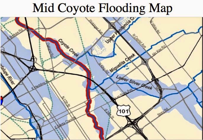
While protecting these homes from flooding, the flood water that is prevented from flowing into its natural bypass channels will add another 2000 CFS of water to the main channel of the creek, greatly increasing the velocity and bank erosion of the roaring river at flood stage. Many large eucalyptus trees and other large riparian trees can be expected to fall and form dams at the bridges, and possibly take homes right off the bank, such as those built on the banks downstream of William Street.It seems that a 35-year old flood diversion channel, built then to protect a new cash register for the City of San Jose called Eastridge, coupled with a flood channelization project that forces even more water into the main channel of the river, in order to protect other homes somewhat remote from the river, is a pretty good case for inverse condemnation of the adjacent creek-side homeowners. Surely these properties will be damaged to a much greater degree when the extra 4000 CFS flows though the main channel of the river, instead of down their natural courses of the Silver Creek to its confluence with Coyote Creek.
The question I raise at this point is this: Should the City of San Jose again fear FEMA and their subrogation lawyers when the next flood occurs in San Jose, and claims are paid by FEMA on homes damaged by the flood that will someday pass through the mid-Coyote?
